Pennsylvania Canal History
Learn about "The Main Line of Public Works"!
In 1824 the state of Pennsylvania authorized construction of the state owned and financed Main Line of Public Works. The Main Line of Public Works, usually referred to as the Pennsylvania Canal, was a hybrid canal, railroad and portage system designed to directly link Pittsburgh and Philadelphia for commerce and travel. Upon completion the main line canal would reduce travel time from Pittsburgh to Philadelphia from 23 days to just 3½ days. The main line would be constructed in four divisions and span a distance of 395 miles. To win the support of the outlying counties the state would also authorize multiple branches and extensions. Construction on the main line was mostly completed between 1826 and 1834 but work on the branches and extensions would continue on until 1858. When work finally ceased the canal had reached a staggering length of nearly 1200 miles. While it’s difficult to comprehend what a monumental undertaking the hand construction of 1200 miles of canal and railroad would be the final cost was even more incomprehensible. The original estimates for construction of the canal system came in at $3 million, a substantial sum now, more substantial then. But by the time construction had come to a close the final cost to the citizens of Pennsylvania would top $50 million. Revenue from the Pennsylvania Canal could not support the expenditure and would nearly bankrupt the state. With losses mounting and public support having evaporated the state sold the canal system to the Pennsylvania Railroad in May of 1855 for $7.5 million. While it failed financially the Pennsylvania Canal was a success in many ways. It had unified the state’s commerce system, established new towns, improved trade with the western territories and laid the foundation for the newer, faster and more reliable railroad network that would take its place. At no time since has the state attempted such a substantial endeavor.
Main Line Divisions
Division No. 1 - The Columbia Railroad (a horse & car railroad), extending from Fairmount water works in Philadelphia to Columbia, a distance of 82 miles. The horses were later replaced by locomotives.
Division No. 2 - The Central Division of the Pennsylvania Canal, extending along the Susquehanna and Juniata Rivers from Columbia to Hollidaysburg, 172 miles. The lockage in this division was 747 feet. There were 18 dams, 33 aqueducts and 101 locks. The canal was forty feet wide at the top, twenty-eight feet wide at the bottom, and four feet deep.
Division No. 3 - Allegheny Portage Railroad, from Hollidaysburg to Johnstown, crossed the crest of the Allegheny Mountains and had a total length of thirty-seven miles. The crossing of the mountains was accomplished by the use of four miles of inclines, consisting of a series of ten separately operated grades, varying in length from 1607 to 3117 feet. Each grade, or plane, was provided at its head with a stationary engine which operated a cable to which were attached the railway cars. On descending grades the cars were gravity propelled and, on level or nearly level grades, first horses, and later locomotives, were used. The ascent from Hollidaysburg to the Summit was 1,398.71 feet in 10.10 miles. The descent to Johnstown was 1751.58 feet in 26-1/2 miles. This stretch of tracks was subsequently relocated and all but one or two of the inclined planes bypassed.
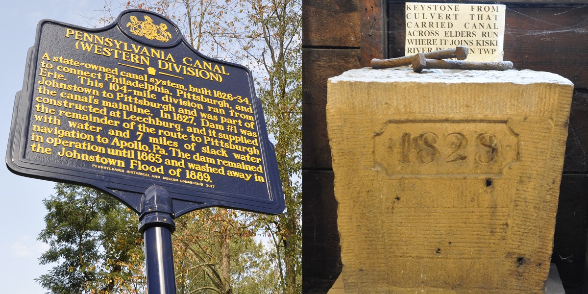
Division No. 4 - The Western Division of the Pennsylvania Canal, extending from Johnstown to Pittsburgh, a distance of 104 miles. The lockage over this portion was 471 feet. To carry this section there were built sixty-four locks, ten dams, two tunnels, sixteen aqueducts, sixty-four culverts, and 152 bridges.
Within Pittsburgh, the canal followed closely the right-of-way now used by the Conemaugh Division (West Penn) of the Pennsylvania Railroad, crossing the Allegheny River at 11th Street by means of an aqueduct. It extended across Penn Avenue, supported by a stone arch bridge, and came to an end in a small basin at Second Avenue. Basins were provided east and west of 11th Street and north of Liberty Avenue, and a larger basin at about the location of present day Grant Street.
Explore local canal history at these Regional Canal Sites.
https://www.nps.gov/jofl/index.htm
https://www.nps.gov/alpo/index.htm
http://www.indianacountyparks.org/parks/tunnelview_park/default.aspx
http://www.saltsburg.org/index.htm
http://www.roaringrun.org/
http://pghbridges.com/articles/canals/canal_history_boucher.htm